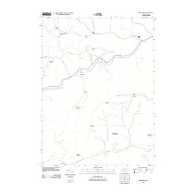
2010 Map of Dents Run
USGS Topo · Published 2010About this map
Bennett Branch Sinnemahoning Creek flows through the center of this rural landscape, carving a deep valley that dictates the placement of early settlements and roads. Small communities like Grant, Sumerson, and Dents Run are concentrated along the waterway, connected by the historical winding path of Dents Run RD. Away from the river, the terrain rises sharply into named elevations like Winslow Hill and Grant Hill, where the land is dominated by significant protected zones including the Marion Brooks Natural Area and the Quehanna Wild Area. For genealogists, the Johnson Cemetery provides a specific point of family history research located near the namesake Johnson Run. The map's labeling of numerous hollows and drafts, such as Dark Hollow and English Draft, illustrates a deeply dissected plateau where drainage patterns like Mix Run and Hicks Run define the local geography.
Find a feature on this map
51 named features on this map. Tap any name to fly to it.
Don’t see what you’re looking for? This feature index may not catch every label — zoom into the map to look around manually.
Map Details
Editions of this 2010 Dents Run Map
This is the sole edition of this map. No revisions or reprints were ever made.
Other maps of this area

1929 · Karthaus
USGS Topo · 1:62,500

1929 · Clearfield
USGS Topo · 1:48,000

1932 · Clearfield
USGS Topo · 1:62,500

1932 · Karthaus
USGS Topo · 1:62,500

1941 · Benezette
USGS Topo · 1:62,500

1943 · Benezette
USGS Topo · 1:62,500

1945 · Driftwood
USGS Topo · 1:48,000

1945 · Driftwood
USGS Topo · 1:24,000

1945 · Cameron
USGS Topo · 1:24,000

1947 · Cameron
USGS Topo · 1:24,000
Featured Places
- Benezette Township, PA
- Grant, Benezette Township
- Sumerson, Benezette Township
- Gibson Township, PA
- Dents Run, Benezette Township