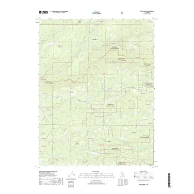
2018 Map of Devils Nose
USGS Topo · Published 2018About this map
Porter and Lily Valley sit within a landscape defined by the deep canyons of the North Fork Mokelumne River and the Middle Fork Mokelumne River. This high-country region on the border of Amador and Calaveras Counties is dominated by the sprawling timberlands of the Eldorado National Forest and Stanislaus National Forest. The map documents a rugged interior geography where water management and logging infrastructure are primary features, evidenced by the Tiger Cr Regulation Reservoir and the winding Tiger Cr Conduit. Prominent topographic landmarks such as Devils Nose, Bald Mtn, and the high reach of Panther Ridge rise above the river forks. Local travel is marked by a network of forest routes and named flats like Boston Flat and Hunter Flat, reflecting the area's history of resource extraction and high-altitude grazing in places like Whitmore Meadow.
Find a feature on this map
71 named features on this map. Tap any name to fly to it.
Don’t see what you’re looking for? This feature index may not catch every label — zoom into the map to look around manually.
Map Details
Editions of this 2018 Devils Nose Map
This is the sole edition of this map. No revisions or reprints were ever made.
Other maps of this area

1889 · Jackson
USGS Topo · 1:125,000

1889 · Pyramid Peak
USGS Topo · 1:125,000

1891 · Big Trees
USGS Topo · 1:125,000

1891 · Placerville
USGS Topo · 1:125,000

1891 · Pyramid Peak
USGS Topo · 1:125,000

1892 · Jackson
USGS Topo · 1:125,000

1892 · Placerville
USGS Topo · 1:125,000

1893 · Placerville
USGS Topo · 1:125,000

1894 · Big Trees
USGS Topo · 1:125,000

1895 · Pyramid Peak
USGS Topo · 1:125,000