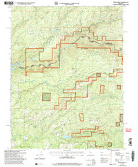
2001 Map of Devils Nose
USGS Topo · Published 2004About this map
Eldorado National Forest and Stanislaus National Forest dominate this landscape, meeting along the winding Mokelumne River corridor. The geography is defined by a series of hydroelectric and water management features, including the Tiger Creek Reservoir, Tiger Creek Forebay, and Tiger Creek Regulatory Res, which support the downstream Powerhouse. The terrain transitions from high ridges like Cooks Station Ridge and the prominent Devils Nose peak down into lush pockets of meadow and flatland. Local transit and access follow historical routes such as Winton Road and Folsom Road, connecting secluded spots like Whitmore Meadow and Hunter Flat. The intricate network of creeks, including Panther Creek and Mill Creek, underscores the vital water resources that have long shaped the boundary between Amador and Calaveras counties.
Find a feature on this map
46 named features on this map. Tap any name to fly to it.
Don’t see what you’re looking for? This feature index may not catch every label — zoom into the map to look around manually.
Map Details
Editions of this 2001 Devils Nose Map
This is the sole edition of this map. No revisions or reprints were ever made.
Other maps of this area

1889 · Jackson
USGS Topo · 1:125,000

1889 · Pyramid Peak
USGS Topo · 1:125,000

1891 · Big Trees
USGS Topo · 1:125,000

1891 · Placerville
USGS Topo · 1:125,000

1891 · Pyramid Peak
USGS Topo · 1:125,000

1892 · Jackson
USGS Topo · 1:125,000

1892 · Placerville
USGS Topo · 1:125,000

1893 · Placerville
USGS Topo · 1:125,000

1894 · Big Trees
USGS Topo · 1:125,000

1895 · Pyramid Peak
USGS Topo · 1:125,000