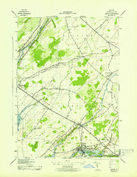
1943 Map of Dexter
USGS Topo · Published 1943About this map
The Black River flows through the village of Dexter, serving as a focal point for this Jefferson County landscape during the early 1940s. Compiled in part from aerial photography, this survey by the Tennessee Valley Authority details a rural economy defined by the New York Central railroad corridor and a network of numbered school districts, from School No 1 near Chaumont to School No 17 further east. The transition from the coastal waters of Guffin Bay to the inland agricultural fields of Brownville and Clayton is punctuated by geological curiosities like the Natural Bridge and high points such as Doanes Hill. Family history is preserved in several burial grounds, including the Freeman Cem and Luther Hill Cem, while the State Game Farm points to the specialized land use in the northern reaches of Hounsfield near Perch River.
Find a feature on this map
40 named features on this map. Tap any name to fly to it.
Don’t see what you’re looking for? This feature index may not catch every label — zoom into the map to look around manually.
Map Details
Editions of this 1943 Dexter Map
This is the sole edition of this map. No revisions or reprints were ever made.
Other maps of this area

1893 · Sackets Harbor
USGS Topo · 1:62,500

1895 · Sacketts Harbor
USGS Topo · 1:62,500

1895 · Watertown
USGS Topo · 1:62,500

1898 · Watertown
USGS Topo · 1:62,500

1900 · Clayton
USGS Topo · 1:62,500

1903 · Clayton
USGS Topo · 1:62,500

1903 · Theresa
USGS Topo · 1:62,500

1908 · Watertown
USGS Topo · 1:62,500

1909 · Watertown
USGS Topo · 1:62,500

1942 · Henderson Bay
USGS Topo · 1:31,680