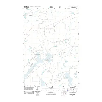
2011 Map of Diamond Lake
USGS Topo · Published 2011About this map
The Lake Owen Summer Homes Group and various recreational landings define this northern Wisconsin landscape as it appeared in 2011. The map detail highlights a dense network of water bodies, including the irregular shoreline of Lake Owen, the smaller Diamond Lake, and isolated basins like Sugar Bush Lake and Ryberg Lake. While the terrain is characterized by these numerous lakes and winding waterways such as Eighteenmile Creek and the Long Lake Branch, the infrastructure is largely composed of United States Forest Service roads, including FR 213 and FR 212. Water management is evident through features like the Lake Owen Dam and the Johnson Springs 3WR211 Dam at the northern end of the quadrangle. For those interested in the seasonal settlement patterns of Bayfield County, the map clearly identifies public recreation areas such as the Two Lakes Campground and the Lake Owen Picnic Area.
Find a feature on this map
70 named features on this map. Tap any name to fly to it.
Don’t see what you’re looking for? This feature index may not catch every label — zoom into the map to look around manually.
Map Details
Editions of this 2011 Diamond Lake Map
This is the sole edition of this map. No revisions or reprints were ever made.
Other maps of this area

1943 · Namekagon Lake
USGS Topo · 1:48,000

1944 · Drummond
USGS Topo · 1:48,000

1944 · Grandview
USGS Topo · 1:48,000

1944 · Hayward
USGS Topo · 1:48,000

1945 · Namekagon Lake
USGS Topo · 1:48,000

1947 · Drummond
USGS Topo · 1:48,000

1947 · Grandview
USGS Topo · 1:48,000

1953 · Ashland
USGS Topo · 1:250,000

1958 · Ashland
USGS Topo · 1:250,000
1971 · Delta
USGS Topo · 1:24,000