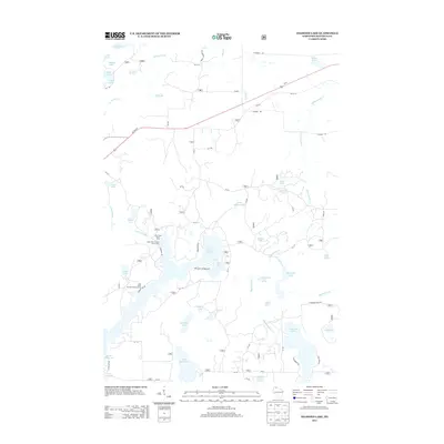
2013 Map of Diamond Lake
USGS Topo · Published 2013About this map
Lake Owen 30 and its surrounding water bodies dominate this portion of Bayfield County, illustrating a landscape defined by glacial kettle lakes and dense forest management. The presence of the Lake Owen Summer Homes Group and the Two Lakes Campground between Bass Lake and Lake Owen 30 highlights the area's twentieth-century evolution into a premier recreation destination within the Chequamegon-Nicolet National Forest. The network of Forest Service roads, such as FR 213, provides access to numerous remote water bodies including Sugar Bush Lake, Deer Lick Lake, and Sage Lake. In the northern section, Us HWY 63 serves as the primary corridor, flanked by older alignments like Old 63 S, while Eighteenmile Creek Springs feeds the complex hydrology of the Eighteenmile Creek drainage system.
Find a feature on this map
67 named features on this map. Tap any name to fly to it.
Don’t see what you’re looking for? This feature index may not catch every label — zoom into the map to look around manually.
Map Details
Editions of this 2013 Diamond Lake Map
This is the sole edition of this map. No revisions or reprints were ever made.
Other maps of this area

1943 · Namekagon Lake
USGS Topo · 1:48,000

1944 · Drummond
USGS Topo · 1:48,000

1944 · Grandview
USGS Topo · 1:48,000

1944 · Hayward
USGS Topo · 1:48,000

1945 · Namekagon Lake
USGS Topo · 1:48,000

1947 · Drummond
USGS Topo · 1:48,000

1947 · Grandview
USGS Topo · 1:48,000

1953 · Ashland
USGS Topo · 1:250,000

1958 · Ashland
USGS Topo · 1:250,000
1971 · Delta
USGS Topo · 1:24,000