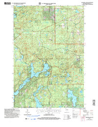
2005 Map of Diamond Lake
USGS Topo · Published 2006About this map
Lake Owen dominates the western portion of this 2005 map, showing a complex shoreline of bays and inlets that serve as a central recreational feature of the Chequamegon-Nicolet National Forest. The landscape is a dense network of glacial kettle lakes and wetlands, where smaller water bodies like Esox Lake, Pot Lake, and Sugar Bush Lake are surrounded by thick woodlands. To the east, the Porcupine Lake Wilderness preserves a more primitive character, centered around Porcupine Lake and the headwaters of Eighteenmile Creek. Local transport and access are defined by forest routes such as North Sweden Road and Gerties Road, while the southern reaches feature the developed Golf Course and several boat access points. This survey reflects a period focused on resource management and conservation in the Great Divide Ranger District, maintaining the balance between timber production and public recreation in northern Wisconsin.
Find a feature on this map
54 named features on this map. Tap any name to fly to it.
Don’t see what you’re looking for? This feature index may not catch every label — zoom into the map to look around manually.
Map Details
Editions of this 2005 Diamond Lake Map
This is the sole edition of this map. No revisions or reprints were ever made.
Other maps of this area

1943 · Namekagon Lake
USGS Topo · 1:48,000

1944 · Drummond
USGS Topo · 1:48,000

1944 · Grandview
USGS Topo · 1:48,000

1944 · Hayward
USGS Topo · 1:48,000

1945 · Namekagon Lake
USGS Topo · 1:48,000

1947 · Drummond
USGS Topo · 1:48,000

1947 · Grandview
USGS Topo · 1:48,000

1953 · Ashland
USGS Topo · 1:250,000

1958 · Ashland
USGS Topo · 1:250,000
1971 · Delta
USGS Topo · 1:24,000