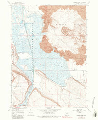
1967 Map of Diamond Swamp
USGS Topo · Published 1981About this map
The Malheur National Wildlife Refuge dominates this volcanic and marshland landscape in Blitzen Valley, where the Donner und Blitzen River feeds a complex network of man-made irrigation. An extensive system of waterways, including the Skunk Canal, Diamond Canal, and South Lane Canal, reveals the engineered effort to manage water within the Diamond Swamp. This intersection of arid geology and managed wetlands is most striking at the border of the Lava flows and the Diamond Craters, which rise sharply above the saturated lowlands.
Find a feature on this map
28 named features on this map. Tap any name to fly to it.
Don’t see what you’re looking for? This feature index may not catch every label — zoom into the map to look around manually.
Map Details
Editions of this 1967 Diamond Swamp Map
3 editions found
Other maps of this area

1955 · Burns
USGS Topo · 1:250,000

1955 · Adel
USGS Topo · 1:250,000

1957 · Adel
USGS Topo · 1:250,000

1958 · Burns
USGS Topo · 1:250,000

1958 · Adel
USGS Topo · 1:250,000

1959 · Burns
USGS Topo · 1:250,000

1962 · Adel
USGS Topo · 1:250,000

1967 · Coyote Buttes
USGS Topo · 1:24,000

1967 · Krumbo Reservoir
USGS Topo · 1:24,000

1967 · Jackass Butte
USGS Topo · 1:24,000