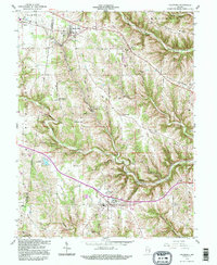
1992 Map of Dillsboro
USGS Topo · Published 1995About this map
The B & O railroad cuts a distinctive path through this corner of Dearborn and Ripley counties, linking the settlements of Milan, Moores Hill, and Dillsboro. This area is characterized by a high density of small family and community burial grounds, such as Forest Hill Cem, Bedunnah Cem, and Olcott Cem, which are scattered among the prominent ridges and deep hollows. The terrain is defined by elevated features like Mount Sinai Ridge and Holman Ridge, with water draining through complex systems like South Hogan Creek and Mud Lick Creek. A notable historical boundary, the Treaty Line, runs diagonally across the western landscape near Hogback Hill, marking an older jurisdictional division in the Indiana territory. Local landmarks like Lake Dilldear and the South Sparta Ch provide anchor points for those studying the rural development and genealogy of these southern Indiana townships.
Find a feature on this map
60 named features on this map. Tap any name to fly to it.
Don’t see what you’re looking for? This feature index may not catch every label — zoom into the map to look around manually.
Map Details
Editions of this 1992 Dillsboro Map
This is the sole edition of this map. No revisions or reprints were ever made.
Other maps of this area

1915 · Lawrenceburg
USGS Topo · 1:48,000

1928 · Lawrenceburg
USGS Topo · 1:62,500

1932 · Lawrenceburg
USGS Topo · 1:62,500

1943 · Aberdeen
USGS Topo · 1:24,000

1943 · Aurora
USGS Topo · 1:24,000

1943 · Guilford
USGS Topo · 1:24,000

1946 · Milan
USGS Topo · 1:24,000

1946 · Pierceville
USGS Topo · 1:24,000

1953 · Aberdeen
USGS Topo · 1:24,000

1953 · Aurora
USGS Topo · 1:24,000