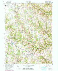
1958 Map of Dillsboro
USGS Topo · Published 1981About this map
Dillsboro and its neighboring villages in Dearborn and Ripley counties appear at a transitional moment when the Baltimore And Ohio railroad still shaped the local economy. The landscape is defined by the branching waters of Hogan Creek, where numerous small hollows like Kruse Hollow and Siefert Hollow cut through the ridges. The settlement at Dillsboro Station highlights the historic separation between the town proper and its rail link. Genealogists will find a dense concentration of family and community burial grounds, including the Forest Hill Cem near Moores Hill and the McKinstry Cem along the North Fork Hogan Creek. The presence of the U S Military Reservation in the southeast and the development of Lake Dildear to the west mark significant shifts in land use across the mid-20th century.
Find a feature on this map
69 named features on this map. Tap any name to fly to it.
Don’t see what you’re looking for? This feature index may not catch every label — zoom into the map to look around manually.
Map Details
Editions of this 1958 Dillsboro Map
3 editions found

Other maps of this area

1915 · Lawrenceburg
USGS Topo · 1:48,000

1928 · Lawrenceburg
USGS Topo · 1:62,500

1932 · Lawrenceburg
USGS Topo · 1:62,500

1943 · Aberdeen
USGS Topo · 1:24,000

1943 · Aurora
USGS Topo · 1:24,000

1943 · Guilford
USGS Topo · 1:24,000

1946 · Milan
USGS Topo · 1:24,000

1946 · Pierceville
USGS Topo · 1:24,000

1953 · Aberdeen
USGS Topo · 1:24,000

1953 · Aurora
USGS Topo · 1:24,000