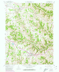
1958 Map of Dillsboro
USGS Topo · Published 1981About this map
Hogan Creek and its many branches, including the North Hogan Creek and South Hogan Creek, define the topography of this southeastern Indiana landscape. The Baltimore and Ohio railroad cuts a major east-west corridor through the terrain, passing through Moores Hill and past Dillsboro Station, illustrating the historical importance of rail transport to the local economy. The area is dotted with numerous family and community burial grounds such as Todd Cem, Heaton Cem, and Union Cem, which provide significant data points for genealogical research.
Find a feature on this map
55 named features on this map. Tap any name to fly to it.
Don’t see what you’re looking for? This feature index may not catch every label — zoom into the map to look around manually.
Map Details
Editions of this 1958 Dillsboro Map
3 editions found

Other maps of this area

1915 · Lawrenceburg
USGS Topo · 1:48,000

1928 · Lawrenceburg
USGS Topo · 1:62,500

1932 · Lawrenceburg
USGS Topo · 1:62,500

1943 · Aberdeen
USGS Topo · 1:24,000

1943 · Aurora
USGS Topo · 1:24,000

1943 · Guilford
USGS Topo · 1:24,000

1946 · Milan
USGS Topo · 1:24,000

1946 · Pierceville
USGS Topo · 1:24,000

1953 · Aberdeen
USGS Topo · 1:24,000

1953 · Aurora
USGS Topo · 1:24,000