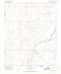
1967 Map of Dinnebito Spring
USGS Topo · Published 1969About this map
The Moenkopi Plateau dominates this high-desert landscape in Coconino County, characterized by a complex intersection of tribal lands during the late 1960s. The map illustrates a significant jurisdictional landscape where the Hopi Indian Reservation meets the Navajo Indian Reservation Joint Use Area, a designation reflecting a specific era of land administration in Northern Arizona. Water sources are the vital anchors of activity in this arid region, marked by the eponymous Dinnebito Spring and Hock Spring, along with the Sweet Water Well. The course of the Dinnebito Wash winds through the terrain, passing near localized clusters of Sand Dunes and ancient Ruins that suggest long-standing human presence. Traces of pastoral life are visible through scattered features like a Corral, situated among the topographic contours and benchmarks established by the Geological Survey during the 1965 aerial photography and 1967 field check.
Find a feature on this map
12 named features on this map. Tap any name to fly to it.
Don’t see what you’re looking for? This feature index may not catch every label — zoom into the map to look around manually.
Map Details
Editions of this 1967 Dinnebito Spring Map
This is the sole edition of this map. No revisions or reprints were ever made.
Other maps of this area

1883 · Tusayan
USGS Topo · 1:250,000

1886 · Tusayan
USGS Topo · 1:250,000

1886 · San Francisco Mtns
USGS Topo · 1:250,000

1891 · San Francisco Mtns
USGS Topo · 1:250,000

1894 · San Francisco Mtns
USGS Topo · 1:250,000

1899 · San Francisco Mtns
USGS Topo · 1:250,000

1947 · Flagstaff
USGS Topo · 1:250,000

1954 · Flagstaff
USGS Topo · 1:250,000

1958 · Flagstaff
USGS Topo · 1:250,000

1960 · Flagstaff
USGS Topo · 1:250,000