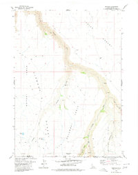
1979 Map of Dishpan
USGS Topo · Published 1980About this map
Jurbidge River and its southern extension, the Jarbidge River, cut through a high desert landscape along the Idaho-Nevada border in this late 1970s survey. The terrain is defined by dramatic plateau features such as Dorsey Table, Diamond Table, and Columbet Table, which rise above the river canyons. Local habitation and ranching history is evidenced by isolated points like the Albert Taylor Place and the settlement of Dishpan.
Find a feature on this map
19 named features on this map. Tap any name to fly to it.
Don’t see what you’re looking for? This feature index may not catch every label — zoom into the map to look around manually.
Map Details
Editions of this 1979 Dishpan Map
This is the sole edition of this map. No revisions or reprints were ever made.
Other maps of this area

1936 · Rowland
USGS Topo · 1:48,000

1940 · Rowland
USGS Topo · 1:62,500

1943 · Jarbidge
USGS Topo · 1:62,500

1945 · Jarbidge
USGS Topo · 1:62,500

1955 · Twin Falls
USGS Topo · 1:250,000

1955 · Wells
USGS Topo · 1:250,000

1958 · Wells
USGS Topo · 1:250,000

1958 · Twin Falls
USGS Topo · 1:250,000

1961 · Wells
USGS Topo · 1:250,000

1978 · The Arch
USGS Topo · 1:24,000