
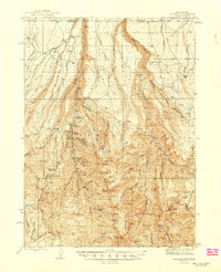
1945 Map of Jarbidge
USGS Topo · Published 1945About this map
Jarbidge sits at the heart of this high-elevation landscape, where the Jarbidge River carves through the Jarbidge Gorge. This 1940s survey reveals an intensive mining landscape within the Humboldt National Forest, specifically along the western slopes above the town. High-altitude operations like the Success Mine, Bluster Mine, and Rex Mine are situated near Bonanza Gulch, illustrating the era's reliance on these mineral-rich peaks.
Find a feature on this map
105 named features on this map. Tap any name to fly to it.
Don’t see what you’re looking for? This feature index may not catch every label — zoom into the map to look around manually.
Map Details
Editions of this 1945 Jarbidge Map
2 editions found
Other maps of this area

1935 · Charleston
USGS Topo · 1:48,000

1936 · Rowland
USGS Topo · 1:48,000

1940 · Rowland
USGS Topo · 1:62,500

1942 · Mt. Velma
USGS Topo · 1:62,500

1943 · Jarbidge
USGS Topo · 1:62,500

1955 · Twin Falls
USGS Topo · 1:250,000

1955 · Wells
USGS Topo · 1:250,000

1957 · Elk Mountain
USGS Topo · 1:62,500

1958 · Wells
USGS Topo · 1:250,000

1958 · Twin Falls
USGS Topo · 1:250,000