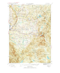
1930 Map of Dixville
USGS Topo · Published 1968About this map
Colebrook and the surrounding townships of the Great North Woods were defined by a landscape of small upland schools and timber-related waterworks during the 1930s. The region is dotted with numerous local schoolhouses such as Piper Hill Sch, Haines Sch, and Mohawk Sch, reflecting a highly localized rural education system before mid-century consolidation. Along the Mohawk River, the map records the State Fish Hatchery and small clusters of settlement at Kidderville and Upper Kidderville. To the east, the dramatic geography of Dixville is anchored by Lake Gloriette and the narrow passage at Dixville Notch Lake. This period also shows the working relationship between the forest and the water, noted by the presence of Kingston Dam and the network of logging camps like Old Ramsay Camp that supported the northern New Hampshire timber economy.
Find a feature on this map
114 named features on this map. Tap any name to fly to it.
Don’t see what you’re looking for? This feature index may not catch every label — zoom into the map to look around manually.
Map Details
Editions of this 1930 Dixville Map
5 editions found
Other maps of this area

1920 · Guildhall
USGS Topo · 1:62,500

1925 · Indian Stream
USGS Topo · 1:48,000

1926 · Indian Stream
USGS Topo · 1:62,500

1927 · Indian Stream
USGS Topo · 1:62,500

1927 · Second Lake
USGS Topo · 1:62,500

1929 · Averill
USGS Topo · 1:62,500

1930 · Milan
USGS Topo · 1:62,500

1930 · Percy
USGS Topo · 1:62,500

1930 · Dixville
USGS Topo · 1:62,500

1930 · Errol
USGS Topo · 1:62,500