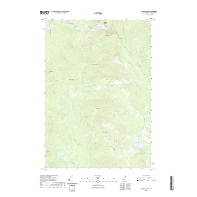
2021 Map of Dixville Notch
USGS Topo · Published 2021About this map
Dixville Notch serves as the focal point of this mountainous landscape in Coos County, defined by its dramatic geologic formations and high-elevation water bodies. Lake Gloriette and Farm Pond sit near the northern pass, while the striking silhouette of Table Rock overlooks the narrow notch. This area is a critical drainage divide, where headwaters like the Mohawk River and various branches of Clear Stream originate from the surrounding peaks. To the south, the terrain levels into significant wetlands and ponds, including Millsfield Pond, The Bog, and the curiously named Devils Washbowl near Phillips Pond. High points such as Dixville Peak and Mt Kelsey anchor a network of forestry roads, including Phillips Brook Rd and Signal Mt Rd, which provide access to this timber-rich portion of New Hampshire.
Find a feature on this map
52 named features on this map. Tap any name to fly to it.
Don’t see what you’re looking for? This feature index may not catch every label — zoom into the map to look around manually.
Map Details
Editions of this 2021 Dixville Notch Map
This is the sole edition of this map. No revisions or reprints were ever made.
Other maps of this area

1930 · Milan
USGS Topo · 1:62,500

1930 · Percy
USGS Topo · 1:62,500

1930 · Dixville
USGS Topo · 1:62,500

1930 · Errol
USGS Topo · 1:62,500

1933 · Dixville
USGS Topo · 1:62,500

1933 · Milan
USGS Topo · 1:62,500

1934 · Percy
USGS Topo · 1:62,500

1934 · Dixville
USGS Topo · 1:62,500

1934 · Errol
USGS Topo · 1:62,500

1934 · Milan
USGS Topo · 1:62,500