
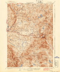
1933 Map of Dixville
USGS Topo · Published 1933About this map
Colebrook and the surrounding townships of Stewartstown and Columbia are shown here as they appeared in the early 1930s. The landscape is defined by the headwaters of the Mohawk River and Simms Stream, where small hillside settlements and numerous schoolhouses supported a dispersed rural population. Educational nodes like Piper Hill Sch, Harvey Swell Sch, and Read Sch highlight the localized nature of the community before widespread school consolidation.
Find a feature on this map
157 named features on this map. Tap any name to fly to it.
Don’t see what you’re looking for? This feature index may not catch every label — zoom into the map to look around manually.
Map Details
Editions of this 1933 Dixville Map
2 editions found
Other maps of this area

1920 · Guildhall
USGS Topo · 1:62,500

1925 · Indian Stream
USGS Topo · 1:48,000

1926 · Indian Stream
USGS Topo · 1:62,500

1927 · Indian Stream
USGS Topo · 1:62,500

1927 · Second Lake
USGS Topo · 1:62,500

1929 · Averill
USGS Topo · 1:62,500

1930 · Milan
USGS Topo · 1:62,500

1930 · Percy
USGS Topo · 1:62,500

1930 · Dixville
USGS Topo · 1:62,500

1930 · Errol
USGS Topo · 1:62,500