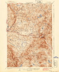
1933 Map of Dixville
USGS Topo · Published 1940About this map
Colebrook serves as the primary hub in this Coos County highland, where the Maine Central railroad corridor meets the Mohawk River. The landscape is dominated by the dramatic passage at Dixville Notch, flanked by Table Rock and the waters of Lake Gloriette. This 1930s survey reveals a dense network of upland school districts and small settlements such as Kidderville and Stewartstown Hollow, reflecting a populated rural economy before the centralization of the mid-twentieth century.
Find a feature on this map
125 named features on this map. Tap any name to fly to it.
Don’t see what you’re looking for? This feature index may not catch every label — zoom into the map to look around manually.
Map Details
Editions of this 1933 Dixville Map
2 editions found

Other maps of this area

1920 · Guildhall
USGS Topo · 1:62,500

1925 · Indian Stream
USGS Topo · 1:48,000

1926 · Indian Stream
USGS Topo · 1:62,500

1927 · Indian Stream
USGS Topo · 1:62,500

1927 · Second Lake
USGS Topo · 1:62,500

1929 · Averill
USGS Topo · 1:62,500

1930 · Milan
USGS Topo · 1:62,500

1930 · Percy
USGS Topo · 1:62,500

1930 · Dixville
USGS Topo · 1:62,500

1930 · Errol
USGS Topo · 1:62,500