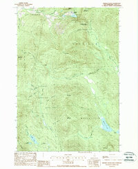
1988 Map of Dixville Notch
USGS Topo · Published 1988About this map
Dixville Notch State Park anchors this mountain landscape, where the dramatic passage of Dixville Notch cuts between the slopes of Abeniki Mountain and Sanguinary Mountain. The geography is defined by sharp elevation changes and landmark formations like Table Rock, looking down upon Lake Gloriette. This 1988 provisional survey details a network of water and wilderness across the town boundaries of Colebrook, Dixville, and Ervings Location. To the south, the terrain levels into the wetlands of The Bog and the secluded waters of Millsfield Pond, Bragg Pond, and Phillips Pond. The map serves as a precise record of the drainage patterns for the Mohawk River and the numerous mountain brooks, such as Flume Brook and Roaring Brook, that carve through the northern forest during this era.
Find a feature on this map
44 named features on this map. Tap any name to fly to it.
Don’t see what you’re looking for? This feature index may not catch every label — zoom into the map to look around manually.
Map Details
Editions of this 1988 Dixville Notch Map
2 editions found
Other maps of this area

1930 · Milan
USGS Topo · 1:62,500

1930 · Percy
USGS Topo · 1:62,500

1930 · Dixville
USGS Topo · 1:62,500

1930 · Errol
USGS Topo · 1:62,500

1933 · Dixville
USGS Topo · 1:62,500

1933 · Milan
USGS Topo · 1:62,500

1934 · Percy
USGS Topo · 1:62,500

1934 · Dixville
USGS Topo · 1:62,500

1934 · Errol
USGS Topo · 1:62,500

1934 · Milan
USGS Topo · 1:62,500