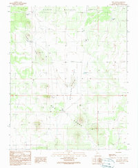
1989 Map of Dog Knobs
USGS Topo · Published 1990About this map
Kai Bab National Forest dominates the northern boundary of this high-country survey, where the terrain shifts from timbered slopes to the wide opening of Antelope Flat. The landscape is defined by its water-scarcity management, evidenced by the numerous catchment points scattered across the Coconino plateau. These include colorfully named features like Suicide Tank, Tarantula Tank, and Johnny Tank, which supported livestock and wildlife in this arid environment long before modern infrastructure reached the interior.
Find a feature on this map
15 named features on this map. Tap any name to fly to it.
Don’t see what you’re looking for? This feature index may not catch every label — zoom into the map to look around manually.
Map Details
Editions of this 1989 Dog Knobs Map
This is the sole edition of this map. No revisions or reprints were ever made.
Other maps of this area

1886 · San Francisco Mtns
USGS Topo · 1:250,000

1886 · Chino
USGS Topo · 1:250,000

1891 · San Francisco Mtns
USGS Topo · 1:250,000

1891 · Chino
USGS Topo · 1:250,000

1894 · San Francisco Mtns
USGS Topo · 1:250,000

1899 · San Francisco Mtns
USGS Topo · 1:250,000

1947 · Flagstaff
USGS Topo · 1:250,000

1948 · Williams
USGS Topo · 1:250,000

1954 · Flagstaff
USGS Topo · 1:250,000

1954 · Williams
USGS Topo · 1:250,000