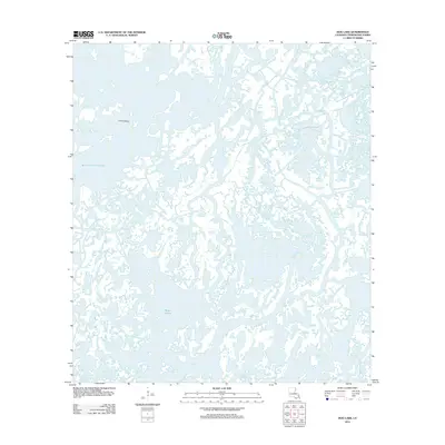
2012 Map of Dog Lake
USGS Topo · Published 2012About this map
China Island stands as a rare terrestrial landmark amidst a complex network of waterways in this coastal Terrebonne Parish landscape. The intricate labyrinth of marshes and bayous is defined by the prominent Bayou Grand Caillou, which serves as a primary arterial channel through the wetlands. Smaller waterways like Post Bayou, Muskrat Bayou, and Bayou Colyell weave through the southern Louisiana delta, reflecting a landscape almost entirely defined by its hydrography. The map also captures specialized passages such as Pass des Illes and the wide expanses of Bayou l'Ourse and Bayou des Illettes. This 2012 survey illustrates the fragile and ever-shifting geometry of the Gulf Coast's marshland, where named features are often water-bound rather than land-based, indicating the area's importance for local navigation and traditional maritime industries.
Find a feature on this map
8 named features on this map. Tap any name to fly to it.
Don’t see what you’re looking for? This feature index may not catch every label — zoom into the map to look around manually.
Map Details
Editions of this 2012 Dog Lake Map
This is the sole edition of this map. No revisions or reprints were ever made.
Other maps of this area

1894 · Bayou De Large
USGS Topo · 1:62,500

1894 · Dulac
USGS Topo · 1:62,500

1935 · Cocodrie
USGS Topo · 1:31,680

1935 · Lake Mechant
USGS Topo · 1:31,680

1935 · Lake Quitman
USGS Topo · 1:31,680

1940 · Bayou Du Large
USGS Topo · 1:62,500

1941 · Bayou Du Large
USGS Topo · 1:62,500

1941 · Dulac
USGS Topo · 1:62,500
1944 · Dulac
USGS Topo · 1:62,500

1944 · Bayou Du Large
USGS Topo · 1:62,500