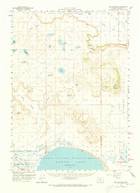
1959 Map of Dog Mountain
USGS Topo · Published 1973About this map
Harney Lake and the northern reaches of the Malheur National Wildlife Refuge anchor this landscape, where the high desert meets a complex system of ephemeral basins and sage valleys. The survey captures a high-water mark for the interior drainage of the Harney Basin, showing numerous named lakes such as Frank Schmidt Lake, Batts Camp Lake, and Albert Lake dotting the northern Sage Hen Valley.
Find a feature on this map
49 named features on this map. Tap any name to fly to it.
Don’t see what you’re looking for? This feature index may not catch every label — zoom into the map to look around manually.
Map Details
Editions of this 1959 Dog Mountain Map
2 editions found
Other maps of this area

1955 · Burns
USGS Topo · 1:250,000

1958 · Burns
USGS Topo · 1:250,000

1959 · Burns
USGS Topo · 1:250,000

1959 · Harney
USGS Topo · 1:62,500

1959 · Dog Mountain
USGS Topo · 1:62,500

1959 · Lawen
USGS Topo · 1:62,500

1960 · Burns
USGS Topo · 1:62,500

1960 · Burns
USGS Topo · 1:24,000

1967 · Coyote Buttes
USGS Topo · 1:24,000

1975 · Burns
USGS Topo · 1:24,000