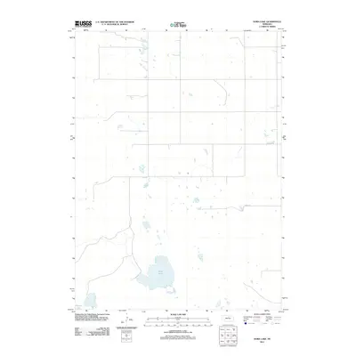
2011 Map of Dora Lake
USGS Topo · Published 2011About this map
Dora Lake and the surrounding wetland complex define this landscape in Holt County during the early 21st century. The terrain is characterized by numerous small, unnamed basins and seasonal water bodies typical of the Nebraska Sandhills, providing a record of the region's unique hydrology before significant modern drainage changes. The presence of Frazier Lake in the southwest and the winding course of Dry Creek to the northeast highlight the delicate balance between permanent water and ephemeral flows. Human infrastructure is limited to a sparse grid of local routes such as 869th Rd, illustrating the low-density grazing and ranching patterns that have long-sustained this part of the state. This survey serves as a clear baseline for tracking shoreline shifts and land-use transitions in a fragile prairie ecosystem.
Find a feature on this map
4 named features on this map. Tap any name to fly to it.
Don’t see what you’re looking for? This feature index may not catch every label — zoom into the map to look around manually.
Map Details
Editions of this 2011 Dora Lake Map
This is the sole edition of this map. No revisions or reprints were ever made.
Other maps of this area

1954 · Stuart
USGS Topo · 1:24,000

1954 · Stuart SE
USGS Topo · 1:24,000

1954 · Newport
USGS Topo · 1:24,000

1955 · O'Neill
USGS Topo · 1:250,000

1959 · O'Neill
USGS Topo · 1:250,000

1969 · O'Neill
USGS Topo · 1:250,000
1982 · Cottonwood Lake
USGS Topo · 1:24,000

1982 · Sybrant
USGS Topo · 1:24,000

1982 · Dora Lake
USGS Topo · 1:24,000
1982 · Pony Lake
USGS Topo · 1:24,000