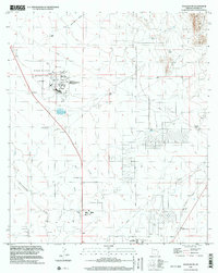
1996 Map of Douglas NE
USGS Topo · Published 2003About this map
Bisbee-Douglas International Airport anchors the landscape of southern Cochise County, surrounded by a transition from industrial infrastructure to open ranch land. This survey captures the development of the region in the late 20th century, notably featuring the Arizona Prison Complex (Douglas) and the sprawling County Fairground. The terrain is defined by dry watercourses such as Mud Springs Draw and the Whitewater Draw, with the deep cleft of Leslie Canyon cutting through the northeast.
Find a feature on this map
23 named features on this map. Tap any name to fly to it.
Don’t see what you’re looking for? This feature index may not catch every label — zoom into the map to look around manually.
Map Details
Editions of this 1996 Douglas NE Map
This is the sole edition of this map. No revisions or reprints were ever made.
Other maps of this area

1914 · Douglas
USGS Topo · 1:62,500

1916 · Pearce
USGS Topo · 1:125,000

1916 · Douglas
USGS Topo · 1:125,000

1917 · Chiricahua
USGS Topo · 1:125,000

1919 · Douglas
USGS Topo · 1:125,000

1919 · Perilla
USGS Topo · 1:125,000

1919 · Chiricahua
USGS Topo · 1:125,000

1922 · Swisshelm
USGS Topo · 1:62,500

1925 · Douglas
USGS Topo · 1:62,500

1926 · Pedregosa
USGS Topo · 1:62,500