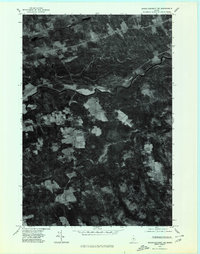
1975 Map of Dover-Foxcroft NE
USGS Topo · Published 1980About this map
Piscataquis River meanders through this mid-1970s orthophotograph, serving as the central geographic feature of a rural landscape defined by woodlots and small clearings. Unlike traditional line maps, this photographic survey reveals the actual texture of the Maine woods and the precise boundaries of agricultural fields near Sebec Corners and Atkinson Corners. The small settlement of South Sebec sits along the river's north bank, while further south, the winding path of Alder Stream leads toward the site of Atkinson Mills. This imagery preserves the exact footprint of these small Piscataquis County communities before modern forest regrowth and changes in local land use altered the visible relationship between the town centers and the surrounding timberland.
Find a feature on this map
6 named features on this map. Tap any name to fly to it.
Don’t see what you’re looking for? This feature index may not catch every label — zoom into the map to look around manually.
Map Details
Editions of this 1975 Dover-Foxcroft NE Map
This is the sole edition of this map. No revisions or reprints were ever made.
Other maps of this area

1932 · Dover-Foxcroft
USGS Topo · 1:48,000

1933 · Boyd Lake
USGS Topo · 1:62,500

1935 · Dover-Foxcroft
USGS Topo · 1:62,500

1940 · Sebec
USGS Topo · 1:48,000

1943 · Sebec
USGS Topo · 1:62,500

1947 · Schoodic
USGS Topo · 1:62,500

1949 · Schoodic
USGS Topo · 1:62,500

1951 · Boyd Lake
USGS Topo · 1:50,000

1954 · Millinocket
USGS Topo · 1:250,000

1955 · Boyd Lake
USGS Topo · 1:62,500