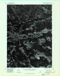
1975 Map of Dover-Foxcroft NW
USGS Topo · Published 1980About this map
The Piscataquis River cuts through the heart of this mid-1970s orthophotoquad, which captures the Piscataquis County landscape through high-altitude aerial imagery. The primary settlement of Dover-Foxcroft is clearly visible, showing the concentration of buildings and infrastructure concentrated along the riverbanks. Surrounding this central hub, smaller rural clusters and road junctions such as Goffs Corner, Hord Corner, and South Dover illustrate the traditional Maine pattern of decentralized rural development. Unlike a standard topographic map, this photographic record provides a direct view of land use, revealing the sharp contrast between cleared agricultural fields and the dense forest canopy. The drainage network is further defined by the winding paths of Alder Stream and Black Stream, while the outlying village of East Dover serves as a secondary point of interest along the river corridor.
Find a feature on this map
8 named features on this map. Tap any name to fly to it.
Don’t see what you’re looking for? This feature index may not catch every label — zoom into the map to look around manually.
Map Details
Editions of this 1975 Dover-Foxcroft NW Map
This is the sole edition of this map. No revisions or reprints were ever made.
Other maps of this area

1932 · Dover-Foxcroft
USGS Topo · 1:48,000

1933 · Guilford
USGS Topo · 1:62,500

1935 · Dover-Foxcroft
USGS Topo · 1:62,500

1937 · Guilford
USGS Topo · 1:62,500

1940 · Sebec
USGS Topo · 1:48,000

1943 · Sebec
USGS Topo · 1:62,500

1950 · Sebec Lake
USGS Topo · 1:62,500

1954 · Millinocket
USGS Topo · 1:250,000

1958 · Millinocket
USGS Topo · 1:250,000

1960 · Millinocket
USGS Topo · 1:250,000