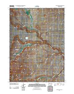
2011 Map of Drake Peak NE
USGS Topo · Published 2011About this map
Fitzgerald Ranch and Taylor Ranch anchor this high-desert ranching landscape in Lake County, where water management is the primary driver of settlement patterns. The topography is defined by a dense network of seasonal drainage and perennial streams, most notably the winding course of Snyder Creek and the confluence of Honey Creek with its many tributaries like Dent Creek and Clover Creek. A significant feature of local infrastructure is Luce Reservoir, which serves as a vital water source for the surrounding cattle operations. The map illustrates a complex web of local roads and 4WD tracks that follow the natural contours of the basin, connecting remote outposts through the drainages of Fort Creek and Deppy Creek. This document captures the modern state of traditional Oregon ranchlands, where name-bearing family operations continue to manage the vast watershed feeding into McDowell Creek and Twelvemile Creek.
Find a feature on this map
13 named features on this map. Tap any name to fly to it.
Don’t see what you’re looking for? This feature index may not catch every label — zoom into the map to look around manually.
Map Details
Editions of this 2011 Drake Peak NE Map
This is the sole edition of this map. No revisions or reprints were ever made.
Other maps of this area

1955 · Klamath Falls
USGS Topo · 1:250,000

1955 · Adel
USGS Topo · 1:250,000

1957 · Adel
USGS Topo · 1:250,000

1958 · Klamath Falls
USGS Topo · 1:250,000

1958 · Adel
USGS Topo · 1:250,000

1962 · Adel
USGS Topo · 1:250,000

1967 · Plush
USGS Topo · 1:24,000

1967 · Rabbit Hills SW
USGS Topo · 1:24,000

1967 · Priday Reservoir
USGS Topo · 1:24,000

1968 · Crook Peak
USGS Topo · 1:24,000