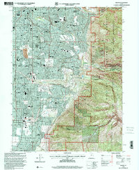
1998 Map of Draper
USGS Topo · Published 2001About this map
Sandy City and Draper show substantial suburban growth in the late 1990s, with a dense network of residential streets and numerous schools like Hillcrest High Sch and Alta High Sch filling the valley floor. The map highlights the sharp transition from this urban development to the protected landscapes of the Wasatch National Forest. To the east, the terrain rises abruptly into the Twin Peaks Wilderness and Lone Peak Wilderness, defined by deep incisions like Bells Canyon and Rocky Mouth Canyon.
Find a feature on this map
75 named features on this map. Tap any name to fly to it.
Don’t see what you’re looking for? This feature index may not catch every label — zoom into the map to look around manually.
Map Details
Editions of this 1998 Draper Map
This is the sole edition of this map. No revisions or reprints were ever made.
Other maps of this area

1885 · Salt Lake
USGS Topo · 1:250,000

1925 · Ft. Douglas
USGS Topo · 1:125,000

1928 · Ft. Douglas
USGS Topo · 1:125,000

1948 · Timpanogos Cave
USGS Topo · 1:24,000

1948 · Orem
USGS Topo · 1:62,500

1950 · Timpanogos Cave
USGS Topo · 1:24,000

1951 · Jordan Narrows
USGS Topo · 1:24,000

1951 · Lehi
USGS Topo · 1:24,000

1951 · Salt Lake City South
USGS Topo · 1:24,000

1951 · Midvale
USGS Topo · 1:24,000