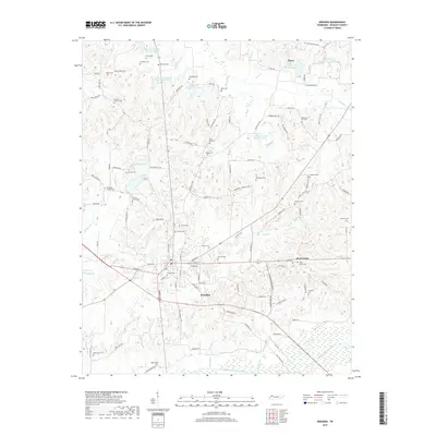
2019 Map of Dresden
USGS Topo · Published 2019About this map
Dresden serves as the focal point of this North Tennessee landscape, situated north of the Middle Fork Obion River. The town is surrounded by a dense network of family cemeteries and small rural settlements like Fancy, Red Hill, and West Union. The terrain is defined by the complex drainage of Cypress Cr, which is marked by a series of numbered reservoirs including Cypress Cr Lake Number Twelve, Cypress Cr Number Ten Lake, and Cypress Cr Lake Number Nine. Genealogists will find a wealth of burial sites across the countryside, from Mcclains Chapel Cem in the west to Travillian Cem in the east. The map illustrates a well-developed road system connecting these remote homesteads and local landmarks such as Rabbit Ranch Rd and Fire Tower Rd.
Find a feature on this map
137 named features on this map. Tap any name to fly to it.
Don’t see what you’re looking for? This feature index may not catch every label — zoom into the map to look around manually.
Map Details
Editions of this 2019 Dresden Map
This is the sole edition of this map. No revisions or reprints were ever made.
Other maps of this area

1950 · Martin
USGS Topo · 1:24,000

1952 · Dresden
USGS Topo · 1:24,000

1954 · Greenfield
USGS Topo · 1:24,000

1956 · Mc Connell
USGS Topo · 1:24,000

1956 · Latham
USGS Topo · 1:24,000
1956 · Palmersville
USGS Topo · 1:24,000

1956 · Dyersburg
USGS Topo · 1:250,000

1957 · Como
USGS Topo · 1:24,000

1967 · Pillowville
USGS Topo · 1:24,000
1967 · Mc Kenzie
USGS Topo · 1:24,000