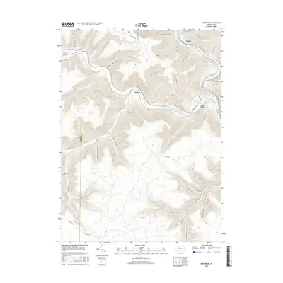
2016 Map of Driftwood
USGS Topo · Published 2016About this map
Driftwood Branch Sinnemahoning Creek and Bennett Branch Sinnemahoning Creek converge in this Pennsylvania mountain landscape, anchoring the historic settlements of Driftwood and Castle Garden. The map illustrates a deeply dissected topography defined by numerous "drafts" and "hollows," including the expansive White Oak Draft and Horsehead Hollow. Genealogists will find several burial grounds preserved here, such as Mix Cem, Hicks Run Cem, and the remote Mason Hill Cem atop Mason Hill. The transition between Elk and Cameron counties is clearly marked as it traverses ridges between Mix Run and Hicks Run. High-elevation features like the Quehanna Track and Quehanna Hwy suggest the area's later focus on conservation and forest management, while the valley roads like Old Rte 555 follow the same natural corridors used by early settlers and loggers.
Find a feature on this map
59 named features on this map. Tap any name to fly to it.
Don’t see what you’re looking for? This feature index may not catch every label — zoom into the map to look around manually.
Map Details
Editions of this 2016 Driftwood Map
This is the sole edition of this map. No revisions or reprints were ever made.
Other maps of this area

1929 · Karthaus
USGS Topo · 1:62,500

1929 · Clearfield
USGS Topo · 1:48,000

1932 · Clearfield
USGS Topo · 1:62,500

1932 · Karthaus
USGS Topo · 1:62,500

1941 · Benezette
USGS Topo · 1:62,500

1943 · Benezette
USGS Topo · 1:62,500

1945 · Driftwood
USGS Topo · 1:48,000

1945 · First Fork
USGS Topo · 1:24,000

1945 · Sinnemahoning
USGS Topo · 1:24,000

1945 · Driftwood
USGS Topo · 1:24,000
Featured Places
- Benezette Township, PA
- Driftwood, PA
- Hicks Run, Gibson Township
- Mix Run, Gibson Township
- Gibson Township, PA