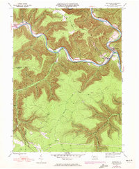
1945 Map of Driftwood
USGS Topo · Published 1972About this map
Bennett Branch Sinnemahoning Creek carves a deep path through the plateau of Cameron and Elk Counties, serving as the primary corridor for settlement and industry in the mid-20th century. Along its banks, the Penn Central railroad tracks follow the winding water, connecting the small communities of Driftwood and Huntley. The landscape is defined by steep, narrow hollows like Horsehead Hollow and Grindstone Hollow that drain into the main branch. Evidence of earlier transport networks remains visible in the Old Railroad Grade north of the river. Higher elevations such as Mason Hill and Gibson show scattered Pipeline corridors and survey markers. Genealogists will find several family and community resting places documented, including Hicks Run Cem and Mix Cem, which anchor the small creek-side settlements.
Find a feature on this map
57 named features on this map. Tap any name to fly to it.
Don’t see what you’re looking for? This feature index may not catch every label — zoom into the map to look around manually.
Map Details
Editions of this 1945 Driftwood Map
3 editions found
Other maps of this area

1929 · Karthaus
USGS Topo · 1:62,500

1929 · Clearfield
USGS Topo · 1:48,000

1932 · Clearfield
USGS Topo · 1:62,500

1932 · Karthaus
USGS Topo · 1:62,500

1941 · Benezette
USGS Topo · 1:62,500

1943 · Benezette
USGS Topo · 1:62,500

1945 · Driftwood
USGS Topo · 1:48,000

1945 · First Fork
USGS Topo · 1:24,000

1945 · Sinnemahoning
USGS Topo · 1:24,000

1945 · Driftwood
USGS Topo · 1:24,000
Featured Places
- Benezette Township, PA
- Driftwood, PA
- Gibson Township, PA
- Castle Garden, Gibson Township
- Mix Run, Gibson Township