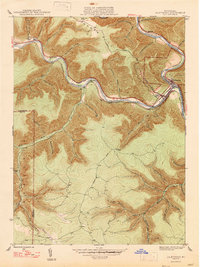
1947 Map of Driftwood
USGS Topo · Published 1947About this map
The confluence of the Driftwood Branch Sinnemahoning Creek and the Bennett Branch Sinnemahoning Creek serves as the geographic heart of this mid-century survey. At this junction lies the town of Driftwood, a hub where the Pennsylvania and Baltimore and Ohio railroads parallel the winding watercourses. The landscape is defined by deeply incised valleys and high plateaus like Mason Hill, with numerous named hollows and drafts such as Archie Barr Hollow and Porcupine Draft carving into the upland terrain.
Find a feature on this map
49 named features on this map. Tap any name to fly to it.
Don’t see what you’re looking for? This feature index may not catch every label — zoom into the map to look around manually.
Map Details
Editions of this 1947 Driftwood Map
2 editions found
Other maps of this area

1929 · Karthaus
USGS Topo · 1:62,500

1929 · Clearfield
USGS Topo · 1:48,000

1932 · Clearfield
USGS Topo · 1:62,500

1932 · Karthaus
USGS Topo · 1:62,500

1941 · Benezette
USGS Topo · 1:62,500

1943 · Benezette
USGS Topo · 1:62,500

1945 · Driftwood
USGS Topo · 1:48,000

1945 · First Fork
USGS Topo · 1:24,000

1945 · Sinnemahoning
USGS Topo · 1:24,000

1945 · Driftwood
USGS Topo · 1:24,000
Featured Places
- Benezette Township, PA
- Driftwood, PA
- Gibson Township, PA
- Castle Garden, Gibson Township
- Mix Run, Gibson Township