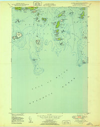
1950 Map of Drisko Island
USGS Topo · Published 1950About this map
Drisko Island and its surrounding archipelago anchor this mid-century maritime survey of Washington County, Maine. The coastal landscape is defined by the narrow passage of Tibbett Narrows and the prominent protrusion of Moose Neck near the northern boundary. Based on hydrographic surveys dating back to 1870, the map meticulously charts the hazards of the Western Bay, including Batson Ledges and the Flat Island Ledges. This documentation captures the intricate shoreline of Cape Split and isolated outposts like Nash Island before decades of North Atlantic weather further reshaped these granite-edged landmasses. The topographic detail reveals the sparse nature of settlement on these islands, focusing instead on the vital relationship between the land and the Gulf of Maine.
Find a feature on this map
46 named features on this map. Tap any name to fly to it.
Don’t see what you’re looking for? This feature index may not catch every label — zoom into the map to look around manually.
Map Details
Editions of this 1950 Drisko Island Map
This is the sole edition of this map. No revisions or reprints were ever made.
Other maps of this area

1902 · Cherryfield
USGS Topo · 1:62,500

1904 · Cherryfield
USGS Topo · 1:62,500

1904 · Petit Manan
USGS Topo · 1:62,500

1921 · Great Wass Island
USGS Topo · 1:62,500

1921 · Columbia Falls
USGS Topo · 1:62,500

1941 · Columbia Falls
USGS Topo · 1:62,500

1942 · Cherryfield
USGS Topo · 1:62,500

1942 · Columbia Falls
USGS Topo · 1:62,500

1948 · Jonesport
USGS Topo · 1:24,000

1948 · Drisko Island
USGS Topo · 1:24,000