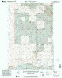
1997 Map of Dry Bullion Creek
USGS Topo · Published 2001About this map
The Little Missouri National Grassland dominates this landscape, showing a portion of the North Dakota badlands as it was managed in the late 1990s. The terrain is defined by the winding course of the Little Missouri River in the south and the drainage networks of Bullion Creek and Dry Bullion Creek farther north. This map captures the intersection of critical survey lines, specifically where the Sixteenth Guide Meridian West meets the Ninth Standard Parallel North on the border of Golden Valley and Slope Counties. Human presence is sparse, limited primarily to isolated ranching operations such as the Howard Ranch and Van Daele Ranch. These features reflect the remote, low-density settlement patterns of the region, where land use was primarily dedicated to grazing and conservation.
Find a feature on this map
11 named features on this map. Tap any name to fly to it.
Don’t see what you’re looking for? This feature index may not catch every label — zoom into the map to look around manually.
Map Details
Editions of this 1997 Dry Bullion Creek Map
This is the sole edition of this map. No revisions or reprints were ever made.
Other maps of this area

1953 · Dickinson
USGS Topo · 1:250,000

1957 · Dickinson
USGS Topo · 1:250,000

1979 · Deep Creek North
USGS Topo · 1:24,000

1979 · Sentinel Butte SE
USGS Topo · 1:24,000

1979 · Three V Crossing
USGS Topo · 1:24,000
1979 · Chimney Butte
USGS Topo · 1:24,000

1979 · Square Butte
USGS Topo · 1:24,000

1979 · Bullion Butte
USGS Topo · 1:24,000

1980 · Spring Creek
USGS Topo · 1:24,000

1980 · Alpha
USGS Topo · 1:24,000