
1957 Map of Dickinson
USGS Topo · Published 1957About this map
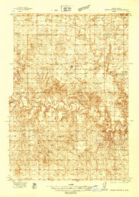
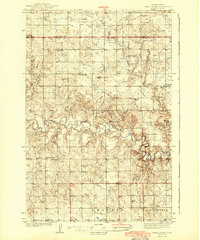
Dickinson serves as the regional hub for the southwestern North Dakota plains, situated along the Northern Pacific railway and the Heart River. In the mid-1950s, this landscape was defined by its coal-rich geology, evidenced by the numerous Strip Mine operations and Coal deposits mapped across the territory. The map reveals a dense network of rural infrastructure, including an extensive series of numbered schoolhouses such as the Fisher School and Hradec School systems, which were vital to the scattered farming and ranching communities of the era.
Find a feature on this map
122 named features on this map. Tap any name to fly to it.
Don’t see what you’re looking for? This feature index may not catch every label — zoom into the map to look around manually.
Map Details
Editions of this 1957 Dickinson Map
This is the sole edition of this map. No revisions or reprints were ever made.
Other maps of this area

1909 · Glendive
USGS Topo · 1:250,000

1935 · Reva
USGS Topo · 1:125,000

1935 · Buffalo
USGS Topo · 1:125,000
1938 · Heart Butte
USGS Topo · 1:48,000
1944 · Heart Butte
USGS Topo · 1:62,500

1953 · McIntosh
USGS Topo · 1:250,000

1953 · Miles City
USGS Topo · 1:250,000

1953 · Dickinson
USGS Topo · 1:250,000

1953 · Watford City
USGS Topo · 1:250,000

1954 · Lemmon
USGS Topo · 1:250,000