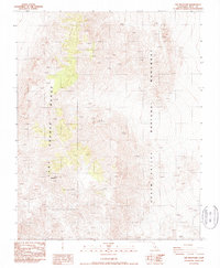
1987 Map of Dry Mountain
USGS Topo · Published 1987About this map
Dry Mountain stands as the central landmark of this high-desert landscape in the northern reaches of Death Valley National Monument. The terrain is dominated by the steep, north-south oriented ridges of the Last Chance Range, where dramatic elevation changes define the character of the region. This 1987 provisional edition represents the area's state in the early 1980s, primarily serving as a record of natural topography and remote wilderness before the monument was reorganized into a national park. The map illustrates a complex network of canyons and peaks with limited human development, focusing on the high-relief geography that transitions from the basin floors to the crest of the range.
Find a feature on this map
4 named features on this map. Tap any name to fly to it.
Don’t see what you’re looking for? This feature index may not catch every label — zoom into the map to look around manually.
Map Details
Editions of this 1987 Dry Mountain Map
This is the sole edition of this map. No revisions or reprints were ever made.
Other maps of this area

1908 · Lida
USGS Topo · 1:250,000

1908 · Ballarat
USGS Topo · 1:250,000

1913 · Lida
USGS Topo · 1:250,000

1913 · Ballarat
USGS Topo · 1:250,000

1948 · Death Valley
USGS Topo · 1:250,000

1954 · Death Valley
USGS Topo · 1:250,000

1954 · Goldfield
USGS Topo · 1:250,000

1955 · Goldfield
USGS Topo · 1:250,000

1956 · Death Valley
USGS Topo · 1:250,000

1957 · Death Valley
USGS Topo · 1:250,000