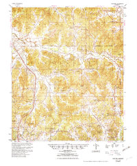
1954 Map of Duck Hill
USGS Topo · Published 1954About this map
The Camp McCain (Abandoned) military site and the Illinois Central Railroad corridor dominate this mid-century survey of the Mississippi hill country. In the years following World War II, the landscape reveals a transition from intensive military training grounds back to rural agricultural and forest land, centered around the settlement of Duck Hill. The map is particularly rich for genealogists, detailing dozens of church and school hubs that served as the social backbone of the region, including Hays Creek Ch Sch, Ch & Cem and St Johns Sch, Ch & Cem. Significant water systems like Big Sand Creek and Little Horse Pen Creek carve through the terrain, while small communities such as Eskridge, Sweatman, and Lodi are meticulously recorded. The presence of a Strip Mine (Abandoned) near Lodi and the widespread power lines reflect the early industrial and utility expansion in Montgomery County and Grenada County.
Find a feature on this map
96 named features on this map. Tap any name to fly to it.
Don’t see what you’re looking for? This feature index may not catch every label — zoom into the map to look around manually.
Map Details
Editions of this 1954 Duck Hill Map
2 editions found
Other maps of this area

1953 · Walthall
USGS Topo · 1:62,500

1953 · West Point
USGS Topo · 1:250,000

1954 · Pittsboro
USGS Topo · 1:62,500

1954 · Grenada
USGS Topo · 1:62,500

1954 · Duck Hill
USGS Topo · 1:62,500

1954 · McCarley
USGS Topo · 1:62,500

1955 · Coffeeville
USGS Topo · 1:62,500

1958 · West Point
USGS Topo · 1:250,000

1963 · West Point
USGS Topo · 1:250,000

1966 · Kilmichael
USGS Topo · 1:24,000