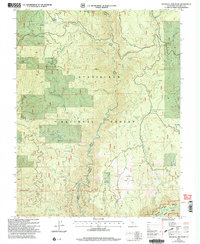
2001 Map of Duckwall Mountain
USGS Topo · Published 2004About this map
Duckwall Mountain and Duckwall Ridge dominate this portion of the Stanislaus National Forest during the transition to the 21st century. The landscape is defined by the deep canyons of the Clavey River and the Tuolumne River, which is designated here as a Scenic and Wild River. Water sources are abundant across the high ground, from the high-elevation Thompson Meadow and Willow Meadow in the north to Bull Meadow in the south. Human activity in these timberlands is marked by the presence of Quinn Ranch and extractive sites such as the Duckwall Quarry and a Rock Pit. This survey captures the managed forest boundaries of the Groveland District Me-Wok, illustrating the network of drainage creeks including Thirteenmile Creek and Jawbone Creek that feed the primary river systems.
Find a feature on this map
37 named features on this map. Tap any name to fly to it.
Don’t see what you’re looking for? This feature index may not catch every label — zoom into the map to look around manually.
Map Details
Editions of this 2001 Duckwall Mountain Map
2 editions found
Other maps of this area

1891 · Big Trees
USGS Topo · 1:125,000

1893 · Sonora
USGS Topo · 1:125,000

1894 · Big Trees
USGS Topo · 1:125,000

1896 · Dardanelles
USGS Topo · 1:125,000

1896 · Sonora
USGS Topo · 1:125,000

1897 · Sonora
USGS Topo · 1:125,000

1897 · Big Trees
USGS Topo · 1:125,000

1897 · Yosemite
USGS Topo · 1:125,000

1898 · Dardanelles
USGS Topo · 1:125,000

1898 · Sonora
USGS Topo · 1:125,000