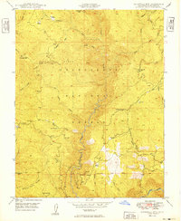
1949 Map of Duckwall Mtn
USGS Topo · Published 1949About this map
The Lumber R.R. winds through the northeast corner of this 1949 survey, tracing a path for timber extraction through the Stanislaus National Forest. The landscape is dominated by the deep drainage of the Clavey River and its numerous tributaries, including Reed Creek and Bear Creek. Evidence of high-country habitation and industry is scattered throughout, from the named settlements of Emmons and Camp 45 to the established Quinn Ranch. Prominent peaks like Duckwall Mtn and Thompson Peak overlook a network of seasonal meadows such as Thompson Meadow and Round Meadow. The presence of the Mt Diablo Base Line serves as a fundamental surveying landmark, while natural springs like Indian Spr and Rackerby Jack Spr mark the importance of water sources in this steep terrain of the central Sierra Nevada foothills.
Find a feature on this map
34 named features on this map. Tap any name to fly to it.
Don’t see what you’re looking for? This feature index may not catch every label — zoom into the map to look around manually.
Map Details
Editions of this 1949 Duckwall Mtn Map
2 editions found
Other maps of this area

1891 · Big Trees
USGS Topo · 1:125,000

1893 · Sonora
USGS Topo · 1:125,000

1894 · Big Trees
USGS Topo · 1:125,000

1896 · Dardanelles
USGS Topo · 1:125,000

1896 · Sonora
USGS Topo · 1:125,000

1897 · Sonora
USGS Topo · 1:125,000

1897 · Big Trees
USGS Topo · 1:125,000

1897 · Yosemite
USGS Topo · 1:125,000

1898 · Dardanelles
USGS Topo · 1:125,000

1898 · Sonora
USGS Topo · 1:125,000