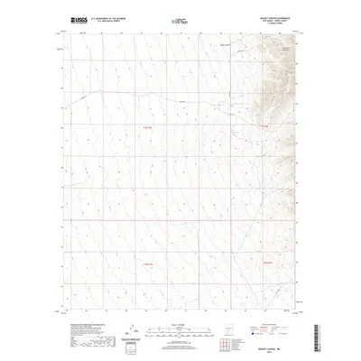
2020 Map of Dugout Canyon
USGS Topo · Published 2020About this map
San Andres Mountains dominate the eastern edge of this Sierra County landscape, where the high desert terrain transitions into steep, ridged slopes. The topography is defined by the significant drainage of Dugout Canyon in the northern reaches, a primary natural feature that dictates the surrounding primitive road network. This 2020 survey illustrates a sparsely populated region largely managed for resource and livestock access, indicated by the presence of water catchments such as BLM Tank and Crispy Tank. These localized water sources are vital landmarks in an arid environment where ranching and land management define the human footprint. Transportation is limited to established county routes and tracks, including Harding Rd and Co Rd A023, which navigate the varying elevations and legal boundaries of t14s r1e and t14s r2e.
Find a feature on this map
12 named features on this map. Tap any name to fly to it.
Don’t see what you’re looking for? This feature index may not catch every label — zoom into the map to look around manually.
Map Details
Editions of this 2020 Dugout Canyon Map
This is the sole edition of this map. No revisions or reprints were ever made.
Other maps of this area

1916 · Tonuco
USGS Topo · 1:125,000

1916 · Salinas Peak
USGS Topo · 1:125,000

1932 · Tonuco
USGS Topo · 1:125,000

1948 · Sowell
USGS Topo · 1:62,500

1948 · Chicken Well
USGS Topo · 1:62,500

1948 · Kaylor Mountain
USGS Topo · 1:62,500

1948 · Black Top Mountain
USGS Topo · 1:62,500

1954 · Tularosa
USGS Topo · 1:250,000

1955 · Las Cruces
USGS Topo · 1:250,000

1958 · Las Cruces
USGS Topo · 1:250,000