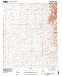
1996 Map of Dugout Canyon
USGS Topo · Published 2002About this map
Dugout Canyon and Chalk Ridge dominate the rugged northeastern corner of this Sierra County landscape, where the terrain transitions toward the high-security border of the White Sands Missile Range. The area is characterized by an extensive network of water management features essential for ranching and survival in the arid high desert, including Mountain Well, High Lonesome Well, and numerous named catchments such as Rabbit Tank and Marys Tank. Human activity is primarily limited to resource extraction and land management, evidenced by several Gravel Pits and a Drill Hole. The presence of BLM Tank reflects federal land oversight, while the web of 4wd tracks suggests a remote environment where movement is dictated by the steep contours and dry washes.
Find a feature on this map
16 named features on this map. Tap any name to fly to it.
Don’t see what you’re looking for? This feature index may not catch every label — zoom into the map to look around manually.
Map Details
Editions of this 1996 Dugout Canyon Map
This is the sole edition of this map. No revisions or reprints were ever made.
Other maps of this area

1916 · Tonuco
USGS Topo · 1:125,000

1916 · Salinas Peak
USGS Topo · 1:125,000

1932 · Tonuco
USGS Topo · 1:125,000

1948 · Sowell
USGS Topo · 1:62,500

1948 · Chicken Well
USGS Topo · 1:62,500

1948 · Kaylor Mountain
USGS Topo · 1:62,500

1948 · Black Top Mountain
USGS Topo · 1:62,500

1954 · Tularosa
USGS Topo · 1:250,000

1955 · Las Cruces
USGS Topo · 1:250,000

1958 · Las Cruces
USGS Topo · 1:250,000