
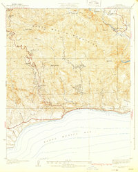
1929 Map of Dume Point
USGS Topo · Published 1929About this map
The Santa Monica Mountains meet the Pacific shoreline in this 1929 survey, which captures the Malibu coast before its era of intensive residential development. The map details a landscape of deep-cut drainage basins including Zuma Canyon and Solstice Canyon, where human activity is largely confined to scattered homesteads and livestock operations. Early landmarks such as the Madley Trading Post and Saddle Rock Lodge reflect the area's emerging status as a destination for travelers along State Route No 60, while the presence of the Decker Sch and family-named holdings like Smiley Place and Bonsall Ranch indicate an established rural community.
Find a feature on this map
27 named features on this map. Tap any name to fly to it.
Don’t see what you’re looking for? This feature index may not catch every label — zoom into the map to look around manually.
Map Details
Editions of this 1929 Dume Point Map
This is the sole edition of this map. No revisions or reprints were ever made.
Other maps of this area

1900 · Triunfo Pass
USGS Topo · 1:62,500

1903 · Camulos
USGS Topo · 1:125,000

1921 · Triunfo Pass
USGS Topo · 1:62,500

1929 · Vejor
USGS Topo · 1:24,000

1929 · Solstice Canyon
USGS Topo · 1:24,000

1932 · Dume Point
USGS Topo · 1:24,000

1932 · Seminole
USGS Topo · 1:24,000

1932 · Russell Valley
USGS Topo · 1:24,000

1932 · Arroyo Sequit
USGS Topo · 1:24,000
1932 · Solstice Canyon
USGS Topo · 1:24,000
Featured Places
- Malibu, CA
- Unincorporated Santa Monica Mountains, CA
- Trancas, Malibu
- Malibu West, Malibu
- Los Angeles County, CA