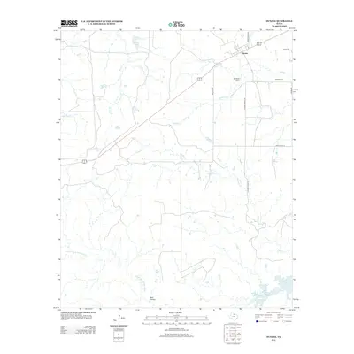
2012 Map of Dundee
USGS Topo · Published 2012About this map
Dundee sits in the northeastern reaches of this Archer County landscape, where the prairie begins to break toward the drainage of the N Fork Little Wichita River. The community's local history is anchored by the Dundee Cem, situated east of the town center near Dundee Rd. Water management is a defining characteristic of this terrain, ranging from the expanse of Lake Kickapoo in the southeast to smaller features like Brushy Tank and Gilmore Lake. The network of local ranch roads, including N Parkey Ranch Rd and Ranch Road 2846, highlights the enduring pastoral nature of the region. Natural drainage patterns are well-defined by numerous waterways such as Holliday Cr, Slippery Cr, and Blackberry Cr, which carve through the land alongside Johnson Draw.
Find a feature on this map
20 named features on this map. Tap any name to fly to it.
Don’t see what you’re looking for? This feature index may not catch every label — zoom into the map to look around manually.
Map Details
Editions of this 2012 Dundee Map
This is the sole edition of this map. No revisions or reprints were ever made.
Other maps of this area

1932 · Dundee
USGS Topo · 1:62,500

1954 · Wichita Falls
USGS Topo · 1:250,000

1958 · Wichita Falls
USGS Topo · 1:250,000

1963 · Dundee
USGS Topo · 1:24,000

1963 · Dundee SW
USGS Topo · 1:24,000

1964 · Dundee SE
USGS Topo · 1:24,000
1966 · Mankins
USGS Topo · 1:24,000

1966 · Franklin Bend
USGS Topo · 1:24,000

1966 · Fulda
USGS Topo · 1:24,000
1966 · Lake Diversion
USGS Topo · 1:24,000