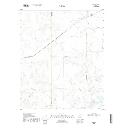
2019 Map of Dundee
USGS Topo · Published 2019About this map
Dundee sits at the northern edge of this North Texas landscape, where the prairie of Archer and Baylor counties is defined by an intricate network of seasonal drainages and cattle tanks. The settlement serves as a focal point for local ranchers, situated near the intersection of several rural routes including Cemetery Rd and Noles Rd. Significant water features like Gilmore Lake and Brushy Tank dot the terrain, while the N Fork Little Wichita River and its various tributaries, such as Holliday Cr and Slippery Cr, carve through the rolling country.
Find a feature on this map
23 named features on this map. Tap any name to fly to it.
Don’t see what you’re looking for? This feature index may not catch every label — zoom into the map to look around manually.
Map Details
Editions of this 2019 Dundee Map
This is the sole edition of this map. No revisions or reprints were ever made.
Other maps of this area

1932 · Dundee
USGS Topo · 1:62,500

1954 · Wichita Falls
USGS Topo · 1:250,000

1958 · Wichita Falls
USGS Topo · 1:250,000

1963 · Dundee
USGS Topo · 1:24,000

1963 · Dundee SW
USGS Topo · 1:24,000

1964 · Dundee SE
USGS Topo · 1:24,000
1966 · Mankins
USGS Topo · 1:24,000

1966 · Franklin Bend
USGS Topo · 1:24,000

1966 · Fulda
USGS Topo · 1:24,000
1966 · Lake Diversion
USGS Topo · 1:24,000