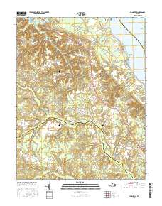
2016 Map of Dunnsville
USGS Topo · Published 2016About this map
The Rappahannock River defines the northeastern edge of this landscape, where waterfront landings like Wares Wharf and Browns Point once facilitated river-borne trade. Further inland, the terrain transitions into the dense marshlands of Dragon Swamp and Exol Swamp, which dominate the southern reach of the survey. The settlement pattern follows the high ground along Tidewater Trl, connecting communities such as Dunnsville, Ozeana, and Center Cross. This corridor reveals a long-established agricultural and timber-linked economy, evidenced by the numerous swamp-draining creeks like Mussel Swamp and Yorkers Swamp. Genealogists may find interest in the centrally located Rappahannock Cem and smaller named locales like Upright, Ino, and Contra that dot the crossroads of Essex and King and Queen counties.
Find a feature on this map
88 named features on this map. Tap any name to fly to it.
Don’t see what you’re looking for? This feature index may not catch every label — zoom into the map to look around manually.
Map Details
Editions of this 2016 Dunnsville Map
This is the sole edition of this map. No revisions or reprints were ever made.
Other maps of this area

1917 · Urbanna
USGS Topo · 1:62,500

1917 · Morattico
USGS Topo · 1:62,500

1918 · Tappahannock
USGS Topo · 1:62,500

1918 · Morattico
USGS Topo · 1:62,500

1919 · New Kent
USGS Topo · 1:62,500

1919 · Tappahannock
USGS Topo · 1:62,500

1926 · Morattico
USGS Topo · 1:62,500

1943 · Richmond
USGS Topo · 1:250,000

1944 · Mount Landing
USGS Topo · 1:31,680

1944 · Tappahannock
USGS Topo · 1:31,680