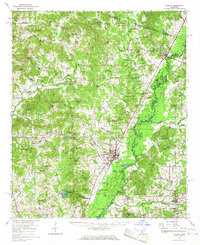
1966 Map of Durant
USGS Topo · Published 1967About this map
The Big Black River meanders through this mid-1960s landscape, serving as a defining geographical marker and county boundary. The rail-oriented economy of Durant and Sallis is evident, where the Illinois Central Railroad intersects with local life at points like Aberdeen Junction. The density of community anchors, such as First Pilgrim Rest Ch and Bethesda Chapel Cem, reflects a deeply rooted rural society organized around faith and family burial grounds.
Find a feature on this map
92 named features on this map. Tap any name to fly to it.
Don’t see what you’re looking for? This feature index may not catch every label — zoom into the map to look around manually.
Map Details
Editions of this 1966 Durant Map
This is the sole edition of this map. No revisions or reprints were ever made.
Other maps of this area

1940 · Seven Pines
USGS Topo · 1:62,500

1940 · Lexington
USGS Topo · 1:62,500

1953 · Meridian
USGS Topo · 1:250,000

1953 · Greenwood
USGS Topo · 1:250,000

1953 · West Point
USGS Topo · 1:250,000

1955 · Jackson
USGS Topo · 1:250,000

1956 · Greenwood
USGS Topo · 1:250,000

1957 · Meridian
USGS Topo · 1:250,000

1957 · Lexington
USGS Topo · 1:62,500

1957 · Seven Pines
USGS Topo · 1:62,500