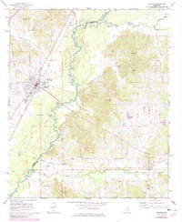
1964 Map of Durant
USGS Topo · Published 1982About this map
The Big Black River meanders across the center of this landscape, marking the boundary between Holmes and Attala counties. In the early 1960s, the rail town of Durant serves as the primary hub, where the Illinois Central Gulf corridor facilitates regional transport. The geography is defined by a heavy concentration of community landmarks, particularly country churches like Second Pilgrim Rest Ch, Macedonia Ch, and Stamp Ridge Ch.
Find a feature on this map
29 named features on this map. Tap any name to fly to it.
Don’t see what you’re looking for? This feature index may not catch every label — zoom into the map to look around manually.
Map Details
Editions of this 1964 Durant Map
2 editions found
Other maps of this area

1953 · Meridian
USGS Topo · 1:250,000

1953 · West Point
USGS Topo · 1:250,000

1957 · Meridian
USGS Topo · 1:250,000

1958 · West Point
USGS Topo · 1:250,000

1962 · Thomastown
USGS Topo · 1:62,500

1963 · West Point
USGS Topo · 1:250,000

1964 · West
USGS Topo · 1:24,000
1964 · Bowling Green
USGS Topo · 1:24,000

1964 · Hesterville
USGS Topo · 1:24,000

1964 · Newport
USGS Topo · 1:24,000