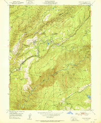
1951 Map of Dutch Flat
USGS Topo · Published 1951About this map
Dutch Flat and the surrounding hydraulic mining landscape of the Sierra Nevada foothills are captured in this 1951 record. The map details a complex network of water engineering necessary for the local economy, including the Boardman Canal, Lowell Hill Canal, and the Dutch Flat Canal. These systems supported both power generation at facilities like the Alta Powerhouse and industrial operations such as the Little York Diggings and Stewart Gravel Mine. The Southern Pacific Railroad winds through the difficult terrain, connecting small settlements like Towle, Baxter, and Midas while navigating deep cuts such as Blue Canyon. Steep vertical relief is evident along Moody Ridge and the North Fork American River, where landmarks like Lovers Leap and Giant Gap define the landscape. This era shows the community of Gold Run with its Gold Run Sch, alongside smaller family-named landmarks and camps like Bonny Nook and Hidden Gold Camp.
Find a feature on this map
70 named features on this map. Tap any name to fly to it.
Don’t see what you’re looking for? This feature index may not catch every label — zoom into the map to look around manually.
Map Details
Editions of this 1951 Dutch Flat Map
This is the sole edition of this map. No revisions or reprints were ever made.
Other maps of this area

1891 · Colfax
USGS Topo · 1:125,000

1892 · Colfax
USGS Topo · 1:125,000

1894 · Colfax
USGS Topo · 1:125,000

1898 · Colfax
USGS Topo · 1:125,000

1900 · Colfax
USGS Topo · 1:125,000

1902 · Colfax
USGS Topo · 1:125,000

1938 · Colfax
USGS Topo · 1:125,000
1948 · Foresthill
USGS Topo · 1:24,000
1949 · Colfax
USGS Topo · 1:24,000

1949 · Chicago Park
USGS Topo · 1:24,000