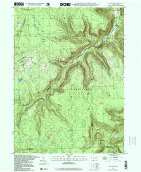
1997 Map of Dutch Mtn
USGS Topo · Published 1999About this map
Bellasylva stands as a primary point of reference in this high-elevation landscape where Sullivan, Wyoming, and Luzerne counties meet. The terrain is characterized by a complex drainage network feeding into Mehoopany Creek and Bowman Creek, with high plateaus like Flat Top and unique geological markers such as The Stack. This map reflects a 1997 photo-inspection of topography originally compiled in the 1940s, capturing a region largely dedicated to conservation and resource management through the Forkston State Game Lands No 57 and SGL No 66.
Find a feature on this map
32 named features on this map. Tap any name to fly to it.
Don’t see what you’re looking for? This feature index may not catch every label — zoom into the map to look around manually.
Map Details
Editions of this 1997 Dutch Mtn Map
This is the sole edition of this map. No revisions or reprints were ever made.
Other maps of this area

1891 · Harveys Lake
USGS Topo · 1:62,500

1893 · Harvey Lake
USGS Topo · 1:62,500

1934 · Laporte
USGS Topo · 1:62,500

1943 · Monroeton
USGS Topo · 1:62,500

1945 · Meshoppen
USGS Topo · 1:62,500

1945 · Jenningsville
USGS Topo · 1:24,000

1945 · Meshoppen
USGS Topo · 1:24,000

1946 · Dutch Mtn
USGS Topo · 1:24,000

1946 · Harveys Lake
USGS Topo · 1:24,000

1946 · Noxen
USGS Topo · 1:24,000
Featured Places
- Noxen Township, PA
- Colley Township, PA
- Forkston Township, PA
- Bellasylva, Forkston Township
- North Branch Township, PA