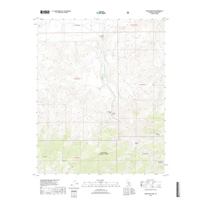
2018 Map of Eagle Rest Peak
USGS Topo · Published 2018About this map
Eagle Rest Peak anchors this high-elevation section of the San Emigdio Mountains within the Los Padres National Forest. The landscape is defined by deep, north-trending drainages such as San Emigdio Canyon and Doc Williams Canyon, which carve through the steep terrain toward the southern edge of the Central Valley. This area has long served as a vital ecological and geological corridor, featuring distinctive landmarks like the Devils Kitchen and the high ridge lines of Blue Ridge and Brush Mtn. San Emigdio Rd follows the canyon floor, providing the primary access through this remote forest territory. Several seasonal waterways, including San Emigdio Cr and Santiago Cr, trace the complex topography of the mountain range.
Find a feature on this map
20 named features on this map. Tap any name to fly to it.
Don’t see what you’re looking for? This feature index may not catch every label — zoom into the map to look around manually.
Map Details
Editions of this 2018 Eagle Rest Peak Map
This is the sole edition of this map. No revisions or reprints were ever made.
Other maps of this area

1903 · Mt. Pinos
USGS Topo · 1:125,000

1910 · Buena Vista Lake
USGS Topo · 1:125,000

1912 · Buena Vista Lake
USGS Topo · 1:125,000

1931 · Pentland Junction
USGS Topo · 1:31,680

1931 · Hayes Ranch
USGS Topo · 1:31,680

1933 · Hayes Ranch
USGS Topo · 1:31,680
1934 · Coal Oil Canyon
USGS Topo · 1:31,680

1934 · Pentland
USGS Topo · 1:31,680

1942 · Eagle Rest Peak
USGS Topo · 1:24,000

1943 · Apache Canyon
USGS Topo · 1:24,000